Showing posts with label geography. Show all posts
Showing posts with label geography. Show all posts
Monday, 27 December 2010


Tuesday, 23 November 2010
Population of African cities to triple: Get the data
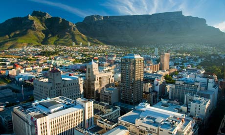
The population of African cities is set to triple over the next 40 years according to a report by UN-HABITAT.
The report entitled The State of African Cities 2010: Governance, Inequalities and Urban Land Markets shows Africa facing a remarkable rise in urban population.
Data
Wednesday, 27 October 2010
Saturday, 25 September 2010
China's one-child policy - success or failure?
On 25 September 1980, the Politburo of the Communist Party issued an "open letter" to all members of the party and the Communist youth league, urging them to take the lead in having only one child.
This is widely seen as the beginning of the controversial one-child policy.
Saturday, 27 February 2010
Massive Earthquake Chile
A massive earthquake with a magnitude of 8.8 has struck central Chile, the country's largest in 25 years.
The quake struck at 0634 GMT about 91km (56 miles) north-east of the city of Concepcion and 317km south-west of the capital, Santiago.
Collapsed buildings have been reported and power loss in Santiago, early warnings of Tsunami (upto 2m recorded levels 1m) have been given, with Hawaii, Japan Alaska and West coast of America on alert.

NOAA Data Buoy centre
 National Atmospheric and Oceanic Administration. Photograph: AFP/Getty Images
Overall, the population in this region resides in structures that are vulnerable to earthquake shaking, though some resistant structures exist. On March 3, 1985 (UTC), a magnitude 7.9 earthquake 311 km North of this one struck Valparaiso, Chile, with estimated population exposures of 5,449,000 at intensity VII and 2,647,000 at intensity VI, resulting in a reported 177 fatalities. Recent earthquakes in this area have caused, tsunamis, landslides and liquefaction that may have contributed to losses.

Population exposure map.
Based on Haiti Earthquake, in which there was a 8% mortality rate, if you extrapolate this for Constitucion with a population of 38K, there is the potential for 3040 deaths and more worrying for Concepcion 215K they could be a potential loss of 17200 people? However large earthquakes have occured in this area in the past with a <% mortality rate, and early indication state that the cities buidlings seem to have resisted well so based on this the death toll could be 1-2000. ( As of March 1st 700+)
Some initial images of damage

Update 1st March 2010
Response
Troops are being deployed to help with rescue efforts and prevent looting. A curfew is in force in some areas. Basic supplies are to be distributed as rescuers reach worst-hit areas.
The army has been sent to support police to prevent unrest in Concepcion, south of Santiago.
The emergency measures announced by Ms Bachelet also include:
- Air force flights to deliver supplies to affected areas
- Free distribution of basic goods in Maule and Biobio regions - distribution points are yet to be decided
- Efforts to guarantee electricity distribution, as many areas remain without power
About 90% of the historic centre of the town of Curico was destroyed. Many roads and bridges across the affected area were damaged or destroyed.
Why the Tsunami wasn't as big as predicted. It's also possible that the fault moved somewhat horizontally, lessening the amount of vertical displacement in the water.
But there are several other reasons why so many fewer people lost their lives this weekend. One is preparedness. Chileans knew what was coming. Reports indicate that alarms were sounded in the town of San Juan Bautista on Robinson Crusoe Islands, for example, possibly saving hundreds of lives.
That preparedness is also reflected in Chile's building codes, another lesson of the 1960 quake. Strong buildings (along with Chile's relative affluence and robust infrastructure) likely saved thousands of lives and prevented this disaster from approaching the magnitude of the continuing horrors in Haiti.
Links @
Discovery NewsMonday, 11 January 2010
Wikitude and Augmented Reality Fieldtrips .
Augmented Reality fieldwork using Wikitude Me.
WIKITUDE World Browser presents the user with data about their surroundings, nearby landmarks, and other points of interest by overlaying information on the real-time camera view of a smart-phone.

WIKITUDE.me, is a community of mobile augmented reality users and shapers, empowered with a powerful tool to embed unique points of interest (POI) and location-specific.

The following video shows how to add POI (Points of Interest) and forms the basic function of creating an Augmented fieldtrip or tour.
The teacher could prepare an Augmented reality fieldtrip by adding a POI (Point of Interest)
along the route which subsequently students could find additional information at relevant points by
launching the Wikiude app or their smartphones .

The camera, GPS and compass is used to calculate where you are in which direction the camera is facing. This allows Wikitude articles that are close to be displayed, these articles or blocks of Wikipedia information could be created prior to the field vist by the lecturer or students could create their own using Wikipedia blocks.

Related Links@-
Saturday, 9 January 2010
Creating Virtual Field Trips using myTracks and Google My Maps.
Create virtual field trip using myTracks Android phone and linking to Google Maps.
Mytracks (Googles hidden gem)
MyTracks is an application for your AndroidTM phone that enables you to record GPS tracks and view live statistics – such as time, speed, distance, and elevation – while hiking, biking, running or participating in other outdoor activities. Once recorded, you can share your tracks, upload them to Google Spreadsheets and visualize them on Google My Maps.
Need an android GPS enabled phone.
 Basic instructions are given on the video, open myTracks application, once GPS fix is established click menu and your are of. As you move mytrack shows you GPS tracks position and elevation.
 You can give your track a name, so it could be a geology field trip, and add a description.
Once you have completed you track/field excursion, you can then send your maps to Google My Maps.
During your Track, you have the ability to geotag locations, which can be edited once you go to Google My Maps and enter the edit function.
Google my maps:-
Once you have created a map, you can:

At each marker point, you can add (formatted) information, pictures and links. This would be useful for descriptive points student could refer to prior to or after a field trip.
You can add photos to your map, as long as they are hosted online, use a service such as Google PicasaWeb to put your photos online.
I have found it best to use panoramio to store and embed into Google Maps, the reason being that Augmented Reality apps such as Layar can be used to view these photos in an "augmented way".

If you want to make this into "Augmented Reality Trip" (i.e by using the Layar app) be aware it can take several weeks for uploaded pictures to be vetted and made public.
Mytracks (Googles hidden gem)
MyTracks is an application for your AndroidTM phone that enables you to record GPS tracks and view live statistics – such as time, speed, distance, and elevation – while hiking, biking, running or participating in other outdoor activities. Once recorded, you can share your tracks, upload them to Google Spreadsheets and visualize them on Google My Maps.
Need an android GPS enabled phone.
 Basic instructions are given on the video, open myTracks application, once GPS fix is established click menu and your are of. As you move mytrack shows you GPS tracks position and elevation.
 You can give your track a name, so it could be a geology field trip, and add a description.
Once you have completed you track/field excursion, you can then send your maps to Google My Maps.
During your Track, you have the ability to geotag locations, which can be edited once you go to Google My Maps and enter the edit function.
Google my maps:-
Once you have created a map, you can:
- Add descriptive text, including rich text and HTML
- Embed photos and videos in your map
- Share your maps with others
- Collaborate with others New!
- Import KML or GeoRSS to your map New!
- Open it in Google Earth

At each marker point, you can add (formatted) information, pictures and links. This would be useful for descriptive points student could refer to prior to or after a field trip.
You can add photos to your map, as long as they are hosted online, use a service such as Google PicasaWeb to put your photos online.
I have found it best to use panoramio to store and embed into Google Maps, the reason being that Augmented Reality apps such as Layar can be used to view these photos in an "augmented way".

If you want to make this into "Augmented Reality Trip" (i.e by using the Layar app) be aware it can take several weeks for uploaded pictures to be vetted and made public.
Subscribe to:
Posts (Atom)