Showing posts with label Earthquakes. Show all posts
Showing posts with label Earthquakes. Show all posts
Wednesday, 27 October 2010


Saturday, 31 July 2010
Further Chile Earthquakes possible.
Chilean authorities are working with seismologists in order to prepare for a possible earthquake that could strike the country "any day".
Research scientist said the 8.8-magnitude earthquake was "the fifth largest event in modern seismology" and prior to the earthquake in February scientists had warned the Chilean government of the possiblilty of a large earhquake and tsunami several months before.

Dr Melnick said "Scientists met with authorities in Talcahuano several months before the earthquake," he told BBC News. "And they warned them that there was a possibility of an earthquake and of a big tsunami.
However the authorities did not take them seriously and believed if you forecast an earthquake people would begin to panic.
Exact forecast
Dr Melnick said that the latest study showed that the predictions were correct, and called February's disaster a "wake-up call" for the local authorities.
The team measured the coastal level changes right after the earthquake to calculate the size of the rupture and then determined how much "slip" was released during the shaking.
Slip is the displacement that results when the tectonic oceanic plate jumps back like a spring during an earthquake after years of compressing the continental plate.
Almost 500 people died during the last earthquake in Chile They found an average slip of 10m - very similar to the forecasted data of 11.9m.
Dr Melnick explained that to predict an earthquake's magnitude, seismologists multiply plate convergence rate by the number of years since the last great event.

"There was an earthquake in south-central Chile in 1835 and it was well documented by FitzRoy and Darwin, [with the data of] land level changes and a tsunami that followed.
"So that means that if we know that a region has not experienced an earthquake in 175 years, then we can say that there is about 11m of slip ready to be released. This way you can estimate the magnitude. And that's very important to know to prepare for it," said Dr Melnick.
Slip displacement and magnitude

Using the same method, scientists determined another area that was "ready" for a potentially devastating shaking - northern Chile, close to the border with Peru.
"The region hasn't ruptured since 1877. We can estimate that it is ready for another magnitude 8 or 8.5 earthquake any day - it could happen tomorrow or it could happen in the years to come," he said.
Resource link @
http://www.bbc.co.uk/news/science-environment-10822259
http://www.fhwa.dot.gov/bridge/tunnel/pubs/nhi09010/13a.cfm
Research scientist said the 8.8-magnitude earthquake was "the fifth largest event in modern seismology" and prior to the earthquake in February scientists had warned the Chilean government of the possiblilty of a large earhquake and tsunami several months before.

Dr Melnick said "Scientists met with authorities in Talcahuano several months before the earthquake," he told BBC News. "And they warned them that there was a possibility of an earthquake and of a big tsunami.
However the authorities did not take them seriously and believed if you forecast an earthquake people would begin to panic.
Exact forecast
Dr Melnick said that the latest study showed that the predictions were correct, and called February's disaster a "wake-up call" for the local authorities.
The team measured the coastal level changes right after the earthquake to calculate the size of the rupture and then determined how much "slip" was released during the shaking.
Slip is the displacement that results when the tectonic oceanic plate jumps back like a spring during an earthquake after years of compressing the continental plate.
Almost 500 people died during the last earthquake in Chile They found an average slip of 10m - very similar to the forecasted data of 11.9m.
Dr Melnick explained that to predict an earthquake's magnitude, seismologists multiply plate convergence rate by the number of years since the last great event.
*Prediction of magnitude= convergence rate x seismic gap(years since last great event)*

"There was an earthquake in south-central Chile in 1835 and it was well documented by FitzRoy and Darwin, [with the data of] land level changes and a tsunami that followed.
"So that means that if we know that a region has not experienced an earthquake in 175 years, then we can say that there is about 11m of slip ready to be released. This way you can estimate the magnitude. And that's very important to know to prepare for it," said Dr Melnick.
Slip displacement and magnitude
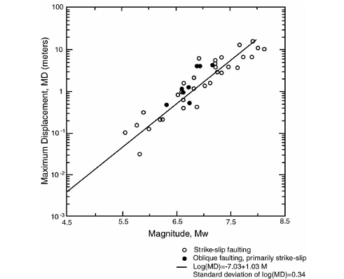
So for example if the expected slip movement is 10m this gives you an approximate earthquake magnitude of over 7.5
Using the same method, scientists determined another area that was "ready" for a potentially devastating shaking - northern Chile, close to the border with Peru.
"The region hasn't ruptured since 1877. We can estimate that it is ready for another magnitude 8 or 8.5 earthquake any day - it could happen tomorrow or it could happen in the years to come," he said.
Resource link @
http://www.bbc.co.uk/news/science-environment-10822259
http://www.fhwa.dot.gov/bridge/tunnel/pubs/nhi09010/13a.cfm
Saturday, 20 March 2010
Earthquake Probability Mapping
USGS Geohazards
This web site was designed to display earthquake probabilities that are computed from the source model of the 2008 USGS-National Seismic Hazard Mapping Project (NSHMP) update.

Suggested Educational use:
Have students pair up or divide into groups and give each group a major US City.
Have student look up Lat and Longitude using Atlases? or online ..(Geographical Skill)
Have students look at the tectonic setting of the cities and based on this have the students suggest the likely probability of a) an earthquake occuring b) possible size eg small, medium or large.c) impact
Then direct them to the USGS Earthquake Probability Mapping site and then, have them run through a series of scenarios e.g. Probaility of a Magnitude 5 occuring within the next 10 years, 20 years and so on, print off their plots in colour(nice for posters).
Summary
Have student collate information and decide which US city has the greatest risk of a large magnitude earthquake (7.0) occuring within the next 10 years.
Extension Activity
Students could look at possible earthquake management schemes that could be implemented, for example retro-fitting supporting columns, prepareness schemes, active monitoring etc
Weblink @
http://geohazards.usgs.gov/eqprob/2009/index.php
http://geohazards.usgs.gov/eqprob/2009/documentation.php
Latitude and Longitude look up
This web site was designed to display earthquake probabilities that are computed from the source model of the 2008 USGS-National Seismic Hazard Mapping Project (NSHMP) update.

Suggested Educational use:
Have students pair up or divide into groups and give each group a major US City.
Have student look up Lat and Longitude using Atlases? or online ..(Geographical Skill)
Have students look at the tectonic setting of the cities and based on this have the students suggest the likely probability of a) an earthquake occuring b) possible size eg small, medium or large.c) impact
Then direct them to the USGS Earthquake Probability Mapping site and then, have them run through a series of scenarios e.g. Probaility of a Magnitude 5 occuring within the next 10 years, 20 years and so on, print off their plots in colour(nice for posters).
Summary
Have student collate information and decide which US city has the greatest risk of a large magnitude earthquake (7.0) occuring within the next 10 years.
Extension Activity
Students could look at possible earthquake management schemes that could be implemented, for example retro-fitting supporting columns, prepareness schemes, active monitoring etc
Weblink @
http://geohazards.usgs.gov/eqprob/2009/index.php
http://geohazards.usgs.gov/eqprob/2009/documentation.php
Latitude and Longitude look up
Monday, 1 March 2010
Saturday, 27 February 2010
Massive Earthquake Chile
A massive earthquake with a magnitude of 8.8 has struck central Chile, the country's largest in 25 years.
The quake struck at 0634 GMT about 91km (56 miles) north-east of the city of Concepcion and 317km south-west of the capital, Santiago.
Collapsed buildings have been reported and power loss in Santiago, early warnings of Tsunami (upto 2m recorded levels 1m) have been given, with Hawaii, Japan Alaska and West coast of America on alert.

NOAA Data Buoy centre
 National Atmospheric and Oceanic Administration. Photograph: AFP/Getty Images
Overall, the population in this region resides in structures that are vulnerable to earthquake shaking, though some resistant structures exist. On March 3, 1985 (UTC), a magnitude 7.9 earthquake 311 km North of this one struck Valparaiso, Chile, with estimated population exposures of 5,449,000 at intensity VII and 2,647,000 at intensity VI, resulting in a reported 177 fatalities. Recent earthquakes in this area have caused, tsunamis, landslides and liquefaction that may have contributed to losses.

Population exposure map.
Based on Haiti Earthquake, in which there was a 8% mortality rate, if you extrapolate this for Constitucion with a population of 38K, there is the potential for 3040 deaths and more worrying for Concepcion 215K they could be a potential loss of 17200 people? However large earthquakes have occured in this area in the past with a <% mortality rate, and early indication state that the cities buidlings seem to have resisted well so based on this the death toll could be 1-2000. ( As of March 1st 700+)
Some initial images of damage

Update 1st March 2010
Response
Troops are being deployed to help with rescue efforts and prevent looting. A curfew is in force in some areas. Basic supplies are to be distributed as rescuers reach worst-hit areas.
The army has been sent to support police to prevent unrest in Concepcion, south of Santiago.
The emergency measures announced by Ms Bachelet also include:
- Air force flights to deliver supplies to affected areas
- Free distribution of basic goods in Maule and Biobio regions - distribution points are yet to be decided
- Efforts to guarantee electricity distribution, as many areas remain without power
About 90% of the historic centre of the town of Curico was destroyed. Many roads and bridges across the affected area were damaged or destroyed.
Why the Tsunami wasn't as big as predicted. It's also possible that the fault moved somewhat horizontally, lessening the amount of vertical displacement in the water.
But there are several other reasons why so many fewer people lost their lives this weekend. One is preparedness. Chileans knew what was coming. Reports indicate that alarms were sounded in the town of San Juan Bautista on Robinson Crusoe Islands, for example, possibly saving hundreds of lives.
That preparedness is also reflected in Chile's building codes, another lesson of the 1960 quake. Strong buildings (along with Chile's relative affluence and robust infrastructure) likely saved thousands of lives and prevented this disaster from approaching the magnitude of the continuing horrors in Haiti.
Links @
Discovery NewsTuesday, 23 February 2010
Saturday, 20 February 2010
Why did so many people die in Haiti's quake?
A comparision between the Chinese earthquake of May 2008, Italian earthquake of July 2009 and the devastating earthquake of Haiti Jan 2010, all measured above magnitude 6.0, but had significantly different impacts. This article by the BBC explains these facts http://news.bbc.co.uk/1/hi/world/americas/8510900.stm


USGS Earthquake Feed Widget, keep upto date with earthquakes from around the world.
Subscribe to:
Posts (Atom)