Residents urged to leave designated danger zone as seismologists warn of pressure
building up beneath smoking crater.
Hazards
"Indonesian scientists have warned of a pressure build-up beneath Mount Merapi's
lava dome, as authorities continue to evacuate tens of thousands of villagers to
temporary shelters.
An avalanche of rocks spilled down Merapi's slopes before dawn on Tuesday
and gusts of ash rose 50 metres into the air as the mountain continued to rumble.
Surono, a government volcanologist, said the greatest concern was pressure
building behind a massive lava dome that has formed near the tip of the crater."
(Merapi Lava Dome 1982)
Geology and Tectonic Setting
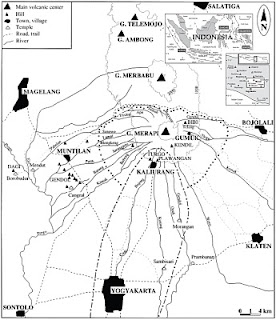
Merapi is a strato-volcano located in Central Java, Indonesia, about 30 km north
of Yogyakarta city which has more than one million inhabitants.
It is produced by subduction of the Australian plate under the Eurasian plate.
The Indonesian archipelago resulted from complex and diverse tectonic processes
(Simandjuntak & Barber, 1996, Wilson 1989, Hamilton, 1979).
Merapi is the most active volcano in Indonesia, erupting regularly since 1548. It is a typical
andesitic Stratovolcano, historically producing effusive eruptions, which have become more
explosive in recent history producing pyroclastic flows from collapsing lava domes. Merapi
usually has poor gas content typically producing eruptions usually less than VEI 3 in size.
Regional Map
26th October 2010
Aftermath of eruption
http://www.bbc.co.uk/news/world-asia-pacific-11633213
The death toll following the eruption of Indonesia's Mount Merapi volcano has risen to 25,
officials say, amid fears of fresh eruptions.
Experts told the BBC that the ash levels had subsided a little, but that their readings
suggested there would be more volcanic activity soon.
Thousands fled their homes on Tuesday as ash spewed out of the volcano,
turning the landscape white.
But many people refused to leave, and rescuers fear the death toll may rise.
Current activity
http://en.wikipedia.org/wiki/Mount_Merapi
BBC Report
http://www.bbc.co.uk/news/world-asia-pacific-11625154
Previous Events
On 13th May 2006 , the Alert Level was raised to the highest level 4, and about
4,500 people living near the volcano were evacuated. On 15th May pyroclastic
flows traveled up to 4 km west.On 8th June, the lava-dome growth rate at Merapi
was an estimated 100,000 cubic meters per day, with an estimated volume of
4 million cubic meters. (
http://www.volcanolive.com/merapi.html)
In late November of 1994, collapse of a lava dome at Merapi generated pyroclastic
flows and surges that travelled as far as 5 miles (7.5 km) from the summit. The flows
and surges killed 43 people. The plume associated with the dome collapse rose 6 miles
(10 km) above the volcano. Over 6,000 people were evacuated. The eruption also started fires. (
http://volcano.oregonstate.edu/oldroot/volcanoes/merapi/merapi.html)
Activity History
http://indahnesia.com/volcano/gunung_merapi/activity_history.php
Related Links@
http://indonesiandisaster.blogspot.com/2010/10/overview-of-merapi-volcano-central-java.html


