Monday, 27 December 2010
Tuesday, 23 November 2010
Population of African cities to triple: Get the data
The population of African cities is set to triple over the next 40 years according to a report by UN-HABITAT.
The report entitled The State of African Cities 2010: Governance, Inequalities and Urban Land Markets shows Africa facing a remarkable rise in urban population.
Data
Thursday, 18 November 2010
Friday, 29 October 2010
Tectonic activity increases across Indonesia!
Mount Merapi volcano has erupted for a third time, with local people reportedly saying this was louder and stronger than the previous eruption on Tuesday. (BBC)
Alert levels have been raised on four other volcanoes, two of which are definitely showing signs of activity - Anak Krakatau and Mount Semeru.

Alert levels have been raised on four other volcanoes, two of which are definitely showing signs of activity - Anak Krakatau and Mount Semeru.

Mount Anak Krakatau, is in the alert status and should not be approached within a radius of 3 kilometers.
the last few days on Mt Anak Krakatau was increasing volcanic earthquake activity.
"From the normally just under 20 times per day, is now volcanic earthquake to 35 times per day. Volcanic ash is also being seen higher, up to 1 kilometer, "said Henry. Friday (29/10/2010)
Now, in Indonesia there are several mountain that is now included in the alert status namely:
1. Karangetan Mount in North Sulawesi,
2. Ibu Mount in Ternate.
3. Sinabung Mount , Karo, North Sumatra
4. Mount Talang, Solok, West Sumatra
5. Mount Anak Krakatau, Lampung
6. Papandayan Mount Garut, West Java
7. Mount Slamet, Tegal, Central Java
8 Mount Dieng, Wonosobo, Central Java
9. Mount Semeru, Lumajang, East Java
10. Mount Bromo, Probolinggo, East Java
Wednesday, 27 October 2010
Tuesday, 26 October 2010
Indonesia Volcano Eruption
| 25th October 2010 Indonesia on volcano eruption alert |
Residents urged to leave designated danger zone as seismologists warn of pressure building up beneath smoking crater. (Reuters) Hazards "Indonesian scientists have warned of a pressure build-up beneath Mount Merapi's lava dome, as authorities continue to evacuate tens of thousands of villagers to temporary shelters. An avalanche of rocks spilled down Merapi's slopes before dawn on Tuesday and gusts of ash rose 50 metres into the air as the mountain continued to rumble. Surono, a government volcanologist, said the greatest concern was pressure building behind a massive lava dome that has formed near the tip of the crater."  Geology and Tectonic Setting Merapi is a strato-volcano located in Central Java, Indonesia, about 30 km north of Yogyakarta city which has more than one million inhabitants. It is produced by subduction of the Australian plate under the Eurasian plate. The Indonesian archipelago resulted from complex and diverse tectonic processes (Simandjuntak & Barber, 1996, Wilson 1989, Hamilton, 1979).  Merapi is the most active volcano in Indonesia, erupting regularly since 1548. It is a typical andesitic Stratovolcano, historically producing effusive eruptions, which have become more explosive in recent history producing pyroclastic flows from collapsing lava domes. Merapi usually has poor gas content typically producing eruptions usually less than VEI 3 in size.   Aftermath of eruption http://www.bbc.co.uk/news/world-asia-pacific-11633213 The death toll following the eruption of Indonesia's Mount Merapi volcano has risen to 25, officials say, amid fears of fresh eruptions. Experts told the BBC that the ash levels had subsided a little, but that their readingssuggested there would be more volcanic activity soon. Thousands fled their homes on Tuesday as ash spewed out of the volcano, turning the landscape white. But many people refused to leave, and rescuers fear the death toll may rise. Current activity http://en.wikipedia.org/wiki/Mount_Merapi BBC Report http://www.bbc.co.uk/news/world-asia-pacific-11625154 Previous Events On 13th May 2006 , the Alert Level was raised to the highest level 4, and about 4,500 people living near the volcano were evacuated. On 15th May pyroclastic flows traveled up to 4 km west.On 8th June, the lava-dome growth rate at Merapi was an estimated 100,000 cubic meters per day, with an estimated volume of 4 million cubic meters. (http://www.volcanolive.com/merapi.html) In late November of 1994, collapse of a lava dome at Merapi generated pyroclastic flows and surges that travelled as far as 5 miles (7.5 km) from the summit. The flows and surges killed 43 people. The plume associated with the dome collapse rose 6 miles (10 km) above the volcano. Over 6,000 people were evacuated. The eruption also started fires. (http://volcano.oregonstate.edu/oldroot/volcanoes/merapi/merapi.html) Activity History http://indahnesia.com/volcano/gunung_merapi/activity_history.php Related Links@ http://indonesiandisaster.blogspot.com/2010/10/overview-of-merapi-volcano-central-java.html |
Saturday, 25 September 2010
China's one-child policy - success or failure?
On 25 September 1980, the Politburo of the Communist Party issued an "open letter" to all members of the party and the Communist youth league, urging them to take the lead in having only one child.
This is widely seen as the beginning of the controversial one-child policy.
Thursday, 23 September 2010
Worlds Largest Wind Farm
The worlds largest offshore wind farm spins into life of the the Kent (Thanet) coast part of the UKs grand plan to provide 20% if its energy by renewable methods.Costing £780 and providing power for over 240,000 homes equivalent to half the houses in Kent, rising two and a half times the height of Nelsons Column.
Links
http://www.engadget.com/2010/09/23/worlds-largest-offshore-wind-farm-spins-into-action-off-the-coa/
Links
http://www.engadget.com/2010/09/23/worlds-largest-offshore-wind-farm-spins-into-action-off-the-coa/
Monday, 30 August 2010
Katrina -Then and Now
A day five years ago that changed the lives of thousands of Americans: the day that Hurricane Katrina made landfall. The water rushed in, the lights went out and for thousands of Gulf Coast residents nothing was ever the same.
CNN have released a video showing with pictures showing the days immediately after hurricane Katrina and now.
However U.S. PRESIDENT BARACK OBAMA: states " I don't have to tell you that there are still too many vacant and overgrown lots. There are still too many students attending classes in trailers. There are still too many people unable to find work. And there are still too many New Orleans folks who haven't been able to come home."
Related Resources @
Free Technology for Teachers (Fiver resources for lesson about Hurricanes)
http://www.freetech4teachers.com/2010/08/five-resources-for-lessons-about.html
Monday, 9 August 2010
The Monsoon and Impacts.
Pakistan Case Studies 2010

Rescuers are struggling to reach 27,000 people still cut off by the floods, which are the worst in 80 years.
At least 1,100 people have died and thousands have lost everything.
"In the worst-affected areas, entire villages were washed away without warning by walls of flood water," the Red Cross said in a statement.
There are fears diarrhoea and cholera will spread among the homeless. Food is scarce and water supplies have been contaminated by the floods.
Video from CNN
Pakistan floods threaten key barrage in southern Sindh
Waters have exceeded the danger level at a key flood barrier in Pakistan's southern province of Sindh.
The Sukkur Barrage flooding means Sindh faces as much devastation as that seen further north in Khyber Pakhtunkhwa and Punjab provinces, say experts.
Enraged survivors have been physically attacking government officials in flood-hit areas, amid widespread anger at the pace of the relief effort.
At least 1,600 people have died in the region's worst deluge in 80 years.
With more than 14 million people already affected, the monsoon rains show little sign of abating.
On Monday, a new international radio initiative called "info-as-aid" made its first broadcasts in Urdu and Pashto in an effort to spread information about accessing aid and also about countering disease.
TV channels 'jammed'
Flood waters have roared down from the north to the agricultural heartland of Punjab and on to Sindh along a trail more than 1,000km (600 miles) long.
In the early hours of Monday morning, the water flow coming down the Sukkur Barrage was recorded at up to 1.4m cusecs (cubic feet per second). It is only designed to withstand 900,000 cusecs.
Upper Sindh is already under water, and rescuers are continuing to evacuate people from the province, where the Indus river banks are at risk of bursting. Two million people have already left the area.
Meanwhile, two major private Pakistani television channels, Geo and Ary, have reportedly been blocked in Karachi and other parts of Sindh.
Prime Minister Yousuf Raza Gilani said the country had been set back years, as he visited Sindh on Sunday.
The entire Swat valley, in north-west Pakistan, was cut off at the weekend, with even helicopters unable to reach it because of the poor weather.
With roads, bridges and railway tracks washed away, and deadly landslides increasing the isolation of many of the worst-hit areas, aid workers are having to use donkeys to deliver relief.
"It's hard to get supplies there. I would like to emphasise we are moving by foot or donkey. We are unable to get in to most places of Swat valley," Maurizio Giuliano, spokesman for the UN Office for the Co-ordination of Humanitarian Affairs, told news agency Reuters.
In the far north of the country, dozens of people were killed on Saturday when two villages were buried in mud and rocks. Nearly 30 bodies were recovered from rubble after landslides in Gilgit-Baltistan province.
The UN has said that Pakistan will need billions of dollars in aid to recover.
Meanwhile, charities with links to militants have been delivering aid to thousands of flood victims, as they did during the earthquake that devastated part of Pakistani-administered Kashmir in 2005.


Rescuers are struggling to reach 27,000 people still cut off by the floods, which are the worst in 80 years.
At least 1,100 people have died and thousands have lost everything.
"In the worst-affected areas, entire villages were washed away without warning by walls of flood water," the Red Cross said in a statement.
There are fears diarrhoea and cholera will spread among the homeless. Food is scarce and water supplies have been contaminated by the floods.
Video from CNN
Waters have exceeded the danger level at a key flood barrier in Pakistan's southern province of Sindh.
The Sukkur Barrage flooding means Sindh faces as much devastation as that seen further north in Khyber Pakhtunkhwa and Punjab provinces, say experts.
Enraged survivors have been physically attacking government officials in flood-hit areas, amid widespread anger at the pace of the relief effort.
At least 1,600 people have died in the region's worst deluge in 80 years.
With more than 14 million people already affected, the monsoon rains show little sign of abating.
On Monday, a new international radio initiative called "info-as-aid" made its first broadcasts in Urdu and Pashto in an effort to spread information about accessing aid and also about countering disease.
TV channels 'jammed'
Flood waters have roared down from the north to the agricultural heartland of Punjab and on to Sindh along a trail more than 1,000km (600 miles) long.
In the early hours of Monday morning, the water flow coming down the Sukkur Barrage was recorded at up to 1.4m cusecs (cubic feet per second). It is only designed to withstand 900,000 cusecs.
Upper Sindh is already under water, and rescuers are continuing to evacuate people from the province, where the Indus river banks are at risk of bursting. Two million people have already left the area.
Meanwhile, two major private Pakistani television channels, Geo and Ary, have reportedly been blocked in Karachi and other parts of Sindh.
Prime Minister Yousuf Raza Gilani said the country had been set back years, as he visited Sindh on Sunday.
The entire Swat valley, in north-west Pakistan, was cut off at the weekend, with even helicopters unable to reach it because of the poor weather.
With roads, bridges and railway tracks washed away, and deadly landslides increasing the isolation of many of the worst-hit areas, aid workers are having to use donkeys to deliver relief.
"It's hard to get supplies there. I would like to emphasise we are moving by foot or donkey. We are unable to get in to most places of Swat valley," Maurizio Giuliano, spokesman for the UN Office for the Co-ordination of Humanitarian Affairs, told news agency Reuters.
In the far north of the country, dozens of people were killed on Saturday when two villages were buried in mud and rocks. Nearly 30 bodies were recovered from rubble after landslides in Gilgit-Baltistan province.
The UN has said that Pakistan will need billions of dollars in aid to recover.
Meanwhile, charities with links to militants have been delivering aid to thousands of flood victims, as they did during the earthquake that devastated part of Pakistani-administered Kashmir in 2005.
Related Links
Uncertainties surround future monsoons(2009)
Pictorial Record of the disaster.
Smos Satellite Tracks Pakistani Floods
Saturday, 31 July 2010
Further Chile Earthquakes possible.
Chilean authorities are working with seismologists in order to prepare for a possible earthquake that could strike the country "any day".
Research scientist said the 8.8-magnitude earthquake was "the fifth largest event in modern seismology" and prior to the earthquake in February scientists had warned the Chilean government of the possiblilty of a large earhquake and tsunami several months before.

Dr Melnick said "Scientists met with authorities in Talcahuano several months before the earthquake," he told BBC News. "And they warned them that there was a possibility of an earthquake and of a big tsunami.
However the authorities did not take them seriously and believed if you forecast an earthquake people would begin to panic.
Exact forecast
Dr Melnick said that the latest study showed that the predictions were correct, and called February's disaster a "wake-up call" for the local authorities.
The team measured the coastal level changes right after the earthquake to calculate the size of the rupture and then determined how much "slip" was released during the shaking.
Slip is the displacement that results when the tectonic oceanic plate jumps back like a spring during an earthquake after years of compressing the continental plate.
Almost 500 people died during the last earthquake in Chile They found an average slip of 10m - very similar to the forecasted data of 11.9m.
Dr Melnick explained that to predict an earthquake's magnitude, seismologists multiply plate convergence rate by the number of years since the last great event.

"There was an earthquake in south-central Chile in 1835 and it was well documented by FitzRoy and Darwin, [with the data of] land level changes and a tsunami that followed.
"So that means that if we know that a region has not experienced an earthquake in 175 years, then we can say that there is about 11m of slip ready to be released. This way you can estimate the magnitude. And that's very important to know to prepare for it," said Dr Melnick.
Slip displacement and magnitude
Using the same method, scientists determined another area that was "ready" for a potentially devastating shaking - northern Chile, close to the border with Peru.
"The region hasn't ruptured since 1877. We can estimate that it is ready for another magnitude 8 or 8.5 earthquake any day - it could happen tomorrow or it could happen in the years to come," he said.
Resource link @
http://www.bbc.co.uk/news/science-environment-10822259
http://www.fhwa.dot.gov/bridge/tunnel/pubs/nhi09010/13a.cfm
Research scientist said the 8.8-magnitude earthquake was "the fifth largest event in modern seismology" and prior to the earthquake in February scientists had warned the Chilean government of the possiblilty of a large earhquake and tsunami several months before.
Dr Melnick said "Scientists met with authorities in Talcahuano several months before the earthquake," he told BBC News. "And they warned them that there was a possibility of an earthquake and of a big tsunami.
However the authorities did not take them seriously and believed if you forecast an earthquake people would begin to panic.
Exact forecast
Dr Melnick said that the latest study showed that the predictions were correct, and called February's disaster a "wake-up call" for the local authorities.
The team measured the coastal level changes right after the earthquake to calculate the size of the rupture and then determined how much "slip" was released during the shaking.
Slip is the displacement that results when the tectonic oceanic plate jumps back like a spring during an earthquake after years of compressing the continental plate.
Almost 500 people died during the last earthquake in Chile They found an average slip of 10m - very similar to the forecasted data of 11.9m.
Dr Melnick explained that to predict an earthquake's magnitude, seismologists multiply plate convergence rate by the number of years since the last great event.
*Prediction of magnitude= convergence rate x seismic gap(years since last great event)*
"There was an earthquake in south-central Chile in 1835 and it was well documented by FitzRoy and Darwin, [with the data of] land level changes and a tsunami that followed.
"So that means that if we know that a region has not experienced an earthquake in 175 years, then we can say that there is about 11m of slip ready to be released. This way you can estimate the magnitude. And that's very important to know to prepare for it," said Dr Melnick.
Slip displacement and magnitude
So for example if the expected slip movement is 10m this gives you an approximate earthquake magnitude of over 7.5
Using the same method, scientists determined another area that was "ready" for a potentially devastating shaking - northern Chile, close to the border with Peru.
"The region hasn't ruptured since 1877. We can estimate that it is ready for another magnitude 8 or 8.5 earthquake any day - it could happen tomorrow or it could happen in the years to come," he said.
Resource link @
http://www.bbc.co.uk/news/science-environment-10822259
http://www.fhwa.dot.gov/bridge/tunnel/pubs/nhi09010/13a.cfm
Sunday, 4 July 2010
Gulf of Mexico Oil Leak Simulation

The cost of cleaning up the oil spillage in the Gulf of Mexico now runs into billions of dollars, according to BP estimates.
The company has tried a number of methods to shut down the leak from the damaged oil well - often innovating as subsequent attempts have failed.

Although some of the methods have been tried and tested at incidents elsewhere in the world, they have not been carried out at such great depth as the Deepwater Horizon leak - 5,000 feet (1.5km) below the surface, see stopping the oil and interactive guide
Links @
http://news.bbc.co.uk/1/hi/science_and_environment/10492086.stmhttp://news.bbc.co.uk/1/hi/world/us_and_canada/10317116.stm
Monday, 26 April 2010
6 volcanoes that could shut down the world
A worrying look at six volcanoes that could have devastating impacts on the world and civilisation.
Here is a taster from the article by the Week.:-
YELLOWSTONE "SUPERVOLCANO" (U.S.)
Last erupted: 640,000 years ago
Effects of a major eruption: When the Yellowstone Caldera, or "supervolcano," in Yellowstone National erupts again, it will render a huge swath of North America, from Vancouver to Oklahoma City, uninhabitable. It would have incalculable human and economic consequences. The last eruption of similar magnitude — 73,000 years ago in Sumatra — plunged the entire planet into a decade-long volcanic winter and nearly wiped out the human race.
Likelihood: Geologists see signs that it could be preparing for another major blowout soon, although "soon" could mean thousands of years.
Volcanic Explosive Index (VEI)of 7

Sources @
Wednesday, 14 April 2010
Sunday, 21 March 2010
The fissure vent eruption on Eyjafjallajokull in Iceland
A volcano in southern Iceland dormant for nearly 200 years erupted back into life earlier today, creating a fissure eruption 1km long within glacier fields of southern Iceland. The eruption as been described as gentle, pictures and reports indicate a fissure eruption; lava flows and ashfall have been seen.
There were initial concerns that it could trigger flooding throught the melting of the overlying glacier however , University of Iceland geologist Tumi Gudumundsson is quoted by ABC News as saying that the eruption is located beneath an ice-free portion of the volcano, lessening the chances of a glacial flood being caused by melted ice.
There is however concern that the initial eruption could trigger more aggressive eruption from the nearby Katla Volcano.
Icelanders agree. "This could trigger Katla, which is a vicious volcano that could cause both local and global damage," Pall Einarsson, from the University of Iceland, said.

Geological setting:-
The ice-cap of the glacier covers an active volcano (1666m in height) which has erupted rather frequently since the ice-age. The last eruption was in 1821-23, causing a fatal glacier run. The crater of the volcano has a diameter of 3-4 km, the glacier covering an extension of about 100 km².
Larger threat:-
"The eruption at Eldgja in ~935 AD lasted 3-8 years and produced 19.6 cubic km of lava, making it the largest basaltic flood lava eruption in historic time. The fissure was about 30 km long. An estimated 219 Mt of SO2 was released to the atmosphere during the eruption which may have produced as much as ~450 Mt of H2SO4 aerosol."
Video of the eruption
Wednesday 13th April
REYKJAVIK - Up to 800 people were evacuated in Iceland early Wednesday due to a volcano eruption under the Eyjafjallajokull glacier in the south of the island, police and geophysicists said.
"Between 700 and 800 people were evacuated from their homes," police spokesman Baldur Sigurdsson told AFP, pointing out that "there were a lot of earthquakes in the area."
"There is an eruption going on in the southwestern part of Eyjafjallajokull's top crater. Smoke coming out of the top crater is towering more than 20,000 feet (6,000 metres) in the air," said geophysicist Gunnar Gunnarsson of Iceland's Meteo Institute.


EUMETSAT Animation of Ash Cloud http://oiswww.eumetsat.org/IPPS/html/MSG/RGB/ASH/ICELAND/
There were initial concerns that it could trigger flooding throught the melting of the overlying glacier however , University of Iceland geologist Tumi Gudumundsson is quoted by ABC News as saying that the eruption is located beneath an ice-free portion of the volcano, lessening the chances of a glacial flood being caused by melted ice.
There is however concern that the initial eruption could trigger more aggressive eruption from the nearby Katla Volcano.
Icelanders agree. "This could trigger Katla, which is a vicious volcano that could cause both local and global damage," Pall Einarsson, from the University of Iceland, said.
Geological setting:-
The ice-cap of the glacier covers an active volcano (1666m in height) which has erupted rather frequently since the ice-age. The last eruption was in 1821-23, causing a fatal glacier run. The crater of the volcano has a diameter of 3-4 km, the glacier covering an extension of about 100 km².
Larger threat:-
"The eruption at Eldgja in ~935 AD lasted 3-8 years and produced 19.6 cubic km of lava, making it the largest basaltic flood lava eruption in historic time. The fissure was about 30 km long. An estimated 219 Mt of SO2 was released to the atmosphere during the eruption which may have produced as much as ~450 Mt of H2SO4 aerosol."
Video of the eruption
Wednesday 13th April
REYKJAVIK - Up to 800 people were evacuated in Iceland early Wednesday due to a volcano eruption under the Eyjafjallajokull glacier in the south of the island, police and geophysicists said.
"Between 700 and 800 people were evacuated from their homes," police spokesman Baldur Sigurdsson told AFP, pointing out that "there were a lot of earthquakes in the area."
"There is an eruption going on in the southwestern part of Eyjafjallajokull's top crater. Smoke coming out of the top crater is towering more than 20,000 feet (6,000 metres) in the air," said geophysicist Gunnar Gunnarsson of Iceland's Meteo Institute.
New Scientist Article
"Volcanologists say the fireworks exploding from the Eyjafjallajökull volcano on Iceland, which is responsible for the ash cloud that is grounding all commercial flights across northern Europe, may become a familiar sight. Increased rumblings under Iceland over the past decade suggest that the area is entering a more active phase,
with more eruptions and the potential for some very large bangs."
"Judging by recent volcanic and earthquake activity, Thordarson and his colleagues believe that Iceland is entering its next active phase and estimate it will last for 60 years or so, peaking between 2030 and 2040."
Journal reference: Geology, vol 26, p 943
Impact on Human Activity
"In 1982, British Airways and Singapore Airways jumbo jets lost all their engines when they flew into an ash cloud over Indonesia."
Reports said that the ash sandblasted the windscreen and clogged the engines, which only restarted when enough of the molten ash solidified and broke off.

"This dust really is nasty stuff," he told BBC News. "It's extremely fine and if it gets into a jet engine, it blocks up all of the ventilation holes that bleed in cooling air.
"Jet engines operate at about 2,000C, and the metals can't take that. The engine will just shut down."
Impact on Human Activity
"In 1982, British Airways and Singapore Airways jumbo jets lost all their engines when they flew into an ash cloud over Indonesia."
Reports said that the ash sandblasted the windscreen and clogged the engines, which only restarted when enough of the molten ash solidified and broke off.
"Jet engines operate at about 2,000C, and the metals can't take that. The engine will just shut down."
Links and additional resources
"We can actually smell sulphur in the air here now from the volcano cloud "Tim Farish, Oslo.
http://news.bbc.co.uk/1/hi/uk/8623806.stm?ls Iceland Volcano ground airflights for second day.
Iceland Why a cloud of ash has grounded flights
http://news.bbc.co.uk/1/hi/sci/tech/8621992.stm
http://news.bbc.co.uk/1/hi/uk/8623806.stm?ls Iceland Volcano ground airflights for second day.
Iceland Why a cloud of ash has grounded flights
http://news.bbc.co.uk/1/hi/sci/tech/8621992.stm
EUMETSAT Animation of Ash Cloud http://oiswww.eumetsat.org/IPPS/html/MSG/RGB/ASH/ICELAND/
Saturday, 20 March 2010
Earthquake Probability Mapping
USGS Geohazards
This web site was designed to display earthquake probabilities that are computed from the source model of the 2008 USGS-National Seismic Hazard Mapping Project (NSHMP) update.

Suggested Educational use:
Have students pair up or divide into groups and give each group a major US City.
Have student look up Lat and Longitude using Atlases? or online ..(Geographical Skill)
Have students look at the tectonic setting of the cities and based on this have the students suggest the likely probability of a) an earthquake occuring b) possible size eg small, medium or large.c) impact
Then direct them to the USGS Earthquake Probability Mapping site and then, have them run through a series of scenarios e.g. Probaility of a Magnitude 5 occuring within the next 10 years, 20 years and so on, print off their plots in colour(nice for posters).
Summary
Have student collate information and decide which US city has the greatest risk of a large magnitude earthquake (7.0) occuring within the next 10 years.
Extension Activity
Students could look at possible earthquake management schemes that could be implemented, for example retro-fitting supporting columns, prepareness schemes, active monitoring etc
Weblink @
http://geohazards.usgs.gov/eqprob/2009/index.php
http://geohazards.usgs.gov/eqprob/2009/documentation.php
Latitude and Longitude look up
Thursday, 11 March 2010
Renewable Energy
What does the future hold for renewable energy? With wind power seeming to dominate on land and offshore, how does wave energy stand up to future energy requirements?
"FROM giant hydraulic oysters that sit on the sea floor, to long rubber snakes that writhe in the ocean swell, there's no shortage of creatures designed to harness the power of the waves. If wave power is to emerge as a viable form of green energy, we need to put them to the test and only the most reliable can expect to survive."
Newscientist Technology
My personal favorite interms of wave energy is the Pelamis Wave Energy Converter which is the result of many years of engineering development by PWP.

However I think that Tidal turbine energy is the route we should be taking; so what are they and why?
Tidal Turbines
‘Conventional’ tidal turbines are of a propeller-based design – similar to a wind turbine – where energy is derived from lift alone. They require a minimum water depth of around 20 to 30m and a relatively high tidal current velocity. Typical efficiency levels are in the 25-35% range – low because of lack of drag utilisation
in the turbine. Even so, they offer real potential to tap tidal energy in larger river estuaries without the need for barrage construction.'

Source:- http://www.greenworldtrust.org.uk/Documents/3rd%20gen%20tidal%20turbines.pdf
Why
Key Environmental Points:-
Links@
http://www.greenworldtrust.org.uk/Documents/3rd%20gen%20tidal%20turbines.pdf
Pelamis Wave Energy Converter
Newscientist Technology
"FROM giant hydraulic oysters that sit on the sea floor, to long rubber snakes that writhe in the ocean swell, there's no shortage of creatures designed to harness the power of the waves. If wave power is to emerge as a viable form of green energy, we need to put them to the test and only the most reliable can expect to survive."
Newscientist Technology
My personal favorite interms of wave energy is the Pelamis Wave Energy Converter which is the result of many years of engineering development by PWP.
However I think that Tidal turbine energy is the route we should be taking; so what are they and why?
Tidal Turbines
‘Conventional’ tidal turbines are of a propeller-based design – similar to a wind turbine – where energy is derived from lift alone. They require a minimum water depth of around 20 to 30m and a relatively high tidal current velocity. Typical efficiency levels are in the 25-35% range – low because of lack of drag utilisation
in the turbine. Even so, they offer real potential to tap tidal energy in larger river estuaries without the need for barrage construction.'

Source:- http://www.greenworldtrust.org.uk/Documents/3rd%20gen%20tidal%20turbines.pdf
Why
- Silent
- Invisible
- Work in shallow environment
- Low footprint but high efficieny
- Low cost technology
Key Environmental Points:-
- The potential power output of the third generation MRev Tidal Turbine could meet or even exceed that of a barrage proposal.
- The use of tidal turbines is unlikely to cause large-scale silting.
- The likely environmental impact is relatively small
Links@
http://www.greenworldtrust.org.uk/Documents/3rd%20gen%20tidal%20turbines.pdf
Pelamis Wave Energy Converter
Newscientist Technology
Monday, 1 March 2010
Saturday, 27 February 2010
Massive Earthquake Chile
A massive earthquake with a magnitude of 8.8 has struck central Chile, the country's largest in 25 years.
The quake struck at 0634 GMT about 91km (56 miles) north-east of the city of Concepcion and 317km south-west of the capital, Santiago.
Collapsed buildings have been reported and power loss in Santiago, early warnings of Tsunami (upto 2m recorded levels 1m) have been given, with Hawaii, Japan Alaska and West coast of America on alert.

NOAA Data Buoy centre
 National Atmospheric and Oceanic Administration. Photograph: AFP/Getty Images
Overall, the population in this region resides in structures that are vulnerable to earthquake shaking, though some resistant structures exist. On March 3, 1985 (UTC), a magnitude 7.9 earthquake 311 km North of this one struck Valparaiso, Chile, with estimated population exposures of 5,449,000 at intensity VII and 2,647,000 at intensity VI, resulting in a reported 177 fatalities. Recent earthquakes in this area have caused, tsunamis, landslides and liquefaction that may have contributed to losses.
Population exposure map.
Based on Haiti Earthquake, in which there was a 8% mortality rate, if you extrapolate this for Constitucion with a population of 38K, there is the potential for 3040 deaths and more worrying for Concepcion 215K they could be a potential loss of 17200 people? However large earthquakes have occured in this area in the past with a <% mortality rate, and early indication state that the cities buidlings seem to have resisted well so based on this the death toll could be 1-2000. ( As of March 1st 700+)
Some initial images of damage

Update 1st March 2010
Response
Troops are being deployed to help with rescue efforts and prevent looting. A curfew is in force in some areas. Basic supplies are to be distributed as rescuers reach worst-hit areas.
The army has been sent to support police to prevent unrest in Concepcion, south of Santiago.
The emergency measures announced by Ms Bachelet also include:
- Air force flights to deliver supplies to affected areas
- Free distribution of basic goods in Maule and Biobio regions - distribution points are yet to be decided
- Efforts to guarantee electricity distribution, as many areas remain without power
About 90% of the historic centre of the town of Curico was destroyed. Many roads and bridges across the affected area were damaged or destroyed.
Why the Tsunami wasn't as big as predicted. It's also possible that the fault moved somewhat horizontally, lessening the amount of vertical displacement in the water.
But there are several other reasons why so many fewer people lost their lives this weekend. One is preparedness. Chileans knew what was coming. Reports indicate that alarms were sounded in the town of San Juan Bautista on Robinson Crusoe Islands, for example, possibly saving hundreds of lives.
That preparedness is also reflected in Chile's building codes, another lesson of the 1960 quake. Strong buildings (along with Chile's relative affluence and robust infrastructure) likely saved thousands of lives and prevented this disaster from approaching the magnitude of the continuing horrors in Haiti.
Links @
Discovery NewsTuesday, 23 February 2010
The online map game Placespotting
placeSpotting.com | The online map game | store
Can you identify this location? Placespotting Quiz for Geography.
Can you identify this location? Placespotting Quiz for Geography.
Monday, 22 February 2010
Flooding and landslides on the Island of Madeira.
At least 38 people have been killed on the Portuguese island of Madeira after severe rainstorms caused flooding and landslides.
Madeira received a months worth of rain in less than eight hours.
Cars were buried, buildings damaged and people swept along in raging waters which swept through the capital, Funchal, on Saturday.
View Larger Map
Madeira, located about 900km (560 miles) from the Portuguese mainland, is popular with foreign tourists.
http://news.bbc.co.uk/1/hi/world/europe/8527589.stm
http://news.bbc.co.uk/1/hi/business/8529239.stm
http://www.cnn.com/2010/WORLD/europe/02/20/portugal.mudslide/?hpt=T2
Madeira received a months worth of rain in less than eight hours.
Cars were buried, buildings damaged and people swept along in raging waters which swept through the capital, Funchal, on Saturday.
View Larger Map
Madeira, located about 900km (560 miles) from the Portuguese mainland, is popular with foreign tourists.
Links @
http://news.bbc.co.uk/1/hi/world/europe/8527589.stm
http://news.bbc.co.uk/1/hi/business/8529239.stm
http://www.cnn.com/2010/WORLD/europe/02/20/portugal.mudslide/?hpt=T2
Saturday, 20 February 2010
Why did so many people die in Haiti's quake?
A comparision between the Chinese earthquake of May 2008, Italian earthquake of July 2009 and the devastating earthquake of Haiti Jan 2010, all measured above magnitude 6.0, but had significantly different impacts. This article by the BBC explains these facts http://news.bbc.co.uk/1/hi/world/americas/8510900.stm

USGS Earthquake Feed Widget, keep upto date with earthquakes from around the world.
Friday, 19 February 2010
Greenland's glaciers disappearing from the bottom up
"Water warmed by climate change is taking giant bites out of the underbellies of Greenland's glaciers. As much as 75 per cent of the ice lost by the glaciers is melted by ocean warmth."

See the full article
Links@
NewScientist
Journal reference: Nature Geoscience, DOI: 10.1038/ngeo765
See the full article
Links@
NewScientist
Journal reference: Nature Geoscience, DOI: 10.1038/ngeo765
Thursday, 18 February 2010
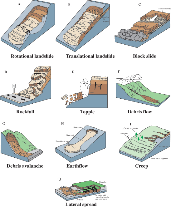
Italian Landslide 16th Feb 2010
A spectacular landslide was caught on camera in the Southern Italian town of Maierato.
It is believe heavy rain may have propogated the slide, which seems to be a translational earthslide.
The 200 or so residents were able to evacute the area and even though the slide passed through the town there were no injuries.
 USGS http://pubs.er.usgs.gov/
It is believe heavy rain may have propogated the slide, which seems to be a translational earthslide.
The 200 or so residents were able to evacute the area and even though the slide passed through the town there were no injuries.
Secrets of Soils
Discover the amazing world of soils with images and information from the Dig It! The Secrets of Soil.
Part of the Smithsonian National Museum of Natural History site.
 Interactive look a the nature, formation and management of soils, videos and online educational activities

Part of the Smithsonian National Museum of Natural History site.

Links @
Monday, 11 January 2010
Wikitude and Augmented Reality Fieldtrips .
Augmented Reality fieldwork using Wikitude Me.
WIKITUDE World Browser presents the user with data about their surroundings, nearby landmarks, and other points of interest by overlaying information on the real-time camera view of a smart-phone.

WIKITUDE.me, is a community of mobile augmented reality users and shapers, empowered with a powerful tool to embed unique points of interest (POI) and location-specific.

The following video shows how to add POI (Points of Interest) and forms the basic function of creating an Augmented fieldtrip or tour.
The teacher could prepare an Augmented reality fieldtrip by adding a POI (Point of Interest)
along the route which subsequently students could find additional information at relevant points by
launching the Wikiude app or their smartphones .

The camera, GPS and compass is used to calculate where you are in which direction the camera is facing. This allows Wikitude articles that are close to be displayed, these articles or blocks of Wikipedia information could be created prior to the field vist by the lecturer or students could create their own using Wikipedia blocks.

Related Links@-
Saturday, 9 January 2010
Creating Virtual Field Trips using myTracks and Google My Maps.
Create virtual field trip using myTracks Android phone and linking to Google Maps.
Mytracks (Googles hidden gem)
MyTracks is an application for your AndroidTM phone that enables you to record GPS tracks and view live statistics – such as time, speed, distance, and elevation – while hiking, biking, running or participating in other outdoor activities. Once recorded, you can share your tracks, upload them to Google Spreadsheets and visualize them on Google My Maps.
Need an android GPS enabled phone.
 Basic instructions are given on the video, open myTracks application, once GPS fix is established click menu and your are of. As you move mytrack shows you GPS tracks position and elevation.
 You can give your track a name, so it could be a geology field trip, and add a description.
Once you have completed you track/field excursion, you can then send your maps to Google My Maps.
During your Track, you have the ability to geotag locations, which can be edited once you go to Google My Maps and enter the edit function.
Google my maps:-
Once you have created a map, you can:

At each marker point, you can add (formatted) information, pictures and links. This would be useful for descriptive points student could refer to prior to or after a field trip.
You can add photos to your map, as long as they are hosted online, use a service such as Google PicasaWeb to put your photos online.
I have found it best to use panoramio to store and embed into Google Maps, the reason being that Augmented Reality apps such as Layar can be used to view these photos in an "augmented way".

If you want to make this into "Augmented Reality Trip" (i.e by using the Layar app) be aware it can take several weeks for uploaded pictures to be vetted and made public.
Mytracks (Googles hidden gem)
MyTracks is an application for your AndroidTM phone that enables you to record GPS tracks and view live statistics – such as time, speed, distance, and elevation – while hiking, biking, running or participating in other outdoor activities. Once recorded, you can share your tracks, upload them to Google Spreadsheets and visualize them on Google My Maps.
Need an android GPS enabled phone.
Once you have completed you track/field excursion, you can then send your maps to Google My Maps.
During your Track, you have the ability to geotag locations, which can be edited once you go to Google My Maps and enter the edit function.
Google my maps:-
Once you have created a map, you can:
- Add descriptive text, including rich text and HTML
- Embed photos and videos in your map
- Share your maps with others
- Collaborate with others New!
- Import KML or GeoRSS to your map New!
- Open it in Google Earth

At each marker point, you can add (formatted) information, pictures and links. This would be useful for descriptive points student could refer to prior to or after a field trip.
You can add photos to your map, as long as they are hosted online, use a service such as Google PicasaWeb to put your photos online.
I have found it best to use panoramio to store and embed into Google Maps, the reason being that Augmented Reality apps such as Layar can be used to view these photos in an "augmented way".

If you want to make this into "Augmented Reality Trip" (i.e by using the Layar app) be aware it can take several weeks for uploaded pictures to be vetted and made public.
Saturday, 2 January 2010
Augmented Reality use in a Geology Field Trip.
Augmented reality (AR) is a term for a live direct or indirect view of a physical real-world environment whose elements are merged with-, or augmented by virtual computer-generated imagery - creating a mixed reality.
What tools are ?available
wikitude (wikipedia) and wikitude me
Layars
Brightkite
My tracks
Google Latitude
Example of augmented Reality and Fieldwork.
Image students armed with a wikitude or Layars enabled smartphone, they reach the first stop on their River or geological field trip.
The teachers says...." OK using your mobile GPS locate and mark on you maps/notes your location and use my track or google latitude to record place mark.
The teacher having previously created a Google maps or a wikipedia entry, with location/placemarks already recorded and information in the form of notes placed on the Google map.
"ok lets look at this location, what is the rock type here? if you are unsure refer to your Augemented Reality notes"....... at this points the student point their phones at the outcrop to see a Google layar showing location 1, clicking on this opens a set of explanatory notes or a set of clues, a close up photo of the rock, or even a youtube video the teacher recorded beforehand on a previous trip.
Augmented Reality on Google Maps using Junaio
Junaio is a mobile and online platform that lets users create, explore and share information using augmented reality and location-based content. Users can place 3D objects, twitter messages or websites into the real world and then share their creations with friends through social networks.
This is an Augmented Reality field trip.
Mark Rollins
Subscribe to:
Posts (Atom)